{ font: $(body.font); color: $(body.text.color); background: $(body.background); padding: opx; $(body.background.override) } expr:class='"loading" + data:blog.mobileClass'>
Showing posts with label Gold Wing. Show all posts

Sunday, July 26, 2015

Take the ByWay!

Planning a trip to Vermont? You must know by now, I love this state, and am very happy to offer this suggestion to the would-be traveler:  If at all possible, take any of these historic Byway routes instead of the Interstate.  Leave the Interstate to the "18-Wheelers" and other trucks. Our byways are not only scenic, but are also a great place for the adventurer. Depending on the byway, our roads can be anywhere from 30 miles, up to 400 miles long!  And yes, just for the record, I have traveled every single one of these byways by car or motorcycle....

Please note:  all links will open in a new window.


Please take a look at this map (PDF) which I found on the Vermont Byways Program website.  If you go to this webpage, scroll to the bottom and click on any of the byway signs for a more detailed map of the area you wish to travel.  I recommend printing the maps in color to put in your glove box or add to your atlas.  Of course, you use your GPS, but they are not always 100% accurate. Here is their website:  http://www.vermont-byways.us/


"Vermont Byways are established from the ground up by local residents taking part in the National Scenic Byways Program, and funded through the Federal Highway Administration. Byway supporters realize their local areas are rich in history, culture, scenic and recreational opportunities. They are proud of their heritage and the place they call home and want to tell their story to you, their guest." Source:  http://www.vermont-byways.us/


Vermont Deadline will tell you that there are 10 Byways in Vermont, to date.  I recommend any of them.  I also recommend stopping in a town and exploring.  Have lunch or dinner, talk to the locals and see what happens....  


Yesterday, we hopped on the Goldwing and headed north through Montpelier, and onto Route 2 to Middlesex.  We took a left onto Route 100 which is the Mad River Byway (detailed larger scale PDF map).  


Route 100 for a day trip is a beautiful choice as the road is in great shape and the mountain scenery is in your face.  I love the peppery scent of cedar and pine that mixes and fills your senses as you drive along this road.  But, driver beware!  Be on the lookout for deer, moose, as well as bicyclists!  Route 100 gives the traveler plenty of opportunities for hiking, canoeing or kayaking.   You can access the Nation's oldest long-distance hiking trail:  The Long Trail or stop by any of the small communities and discover their secrets.  

Photo: yourplacevermont.com
Byways are the very best option to discover quaint villages, who sell local Vermont products.  You can find local maple syrup and dairy products to natural soaps to handmade arts and crafts in various mediums.  


You can stop along side the byway to dip your feet or swim in the Mad River or stand at an amazing waterfall to have your picture taken! There are plenty of historic sites to visit and great places to eat, and taverns to drink (link to D's Dog House, Granville where you can sometimes be lucky enough to hear the Band "CRUISE CONTROL").  The bucolic settings offers plenty of photo opps such as many steeple churches, town greens, vast countryside with the Green Mountains as a back-drop and lots of native farms, as well as covered bridges! There are also chances to play golf, to go fishing, camping, skiing, snowboarding or to play tennis....and the list goes on!


Old Rusty with his "baby"
The road we chose, took us through Moretown, Waitsfield, Warren, and into Granville.  Below Waitsfield, is the Town of Irasville, where you can turn onto Route 17 which is also part of the Mad River Byway and will take you to Baby Stark, Molly Stark and Beane Mountains, respectfully.

madrivervalley.com offers this description:

A 2.6 mile round-trip hike that gains over 500' of elevation to a unique lookout. From Rt. 17 you hike north on the Long Trail, which climbs steeply, passes a spur to the Mad River Glen Lookout, then reaches a high point at the flat ridge of Molly Stark Mountain summit. The trail goes over the summit and on to Molly Stark's Balcony where there is a great view of Camel's Hump, the intervening peaks, with the Worcester Mountains visible to the east.

In Waitsfield, Russ and I walked through the Vermont Festival of the Arts, which was a public, outdoor event. There was plenty of food to sample, a band was playing and a multitude of various local artisan's selling their wares.


Before arriving in Rochester, we passed "Genes Road", and I couldn't help but wonder, is this were people find their routes [roots]?  Bad joke, I know...but my mind tends to wander on the back of the bike....
Great food, great service, great local folk and Cousin Cora works there 
We continued down the byway below Granville and arrived in Rochester where we ate lunch at Sandy's Books and Bakery  as the Rochester Cafe was packed and not a single seat left!  In the gorgeous town of Rochester, you can discover a variety of fun stores, and a large and beautiful town Green, complete with a gazebo.  Rochester hosts their Summer Concert Series here, and artists naturally gravitate to this area to build their businesses and to live, respectfully.  


Rochester's "Green" in the fall
After lunch, we continued south but then turned onto Route 73 (still in Rochester) through Goshen toward Middlebury. Here, the road will take you onto the bottom of the Lake Champlain Byway (Route 7).  The Lake Champlain Byway is another fantastic road to take for a day trip, as this will bring you north into Vermont's Islands District. You can continue straight north into Canada in Alburgh


On Route 73, you travel through the town of Forest Dale (which is either a hamlet of, or part of the town of Brandon). I thought to myself, I want to live in a town by this name!  I pictured fairies dancing in backyards, Celtic music playing and people dressed in Ren Faire clothing.... but alas!  It was just a passing fancy as we drove through. 

Lilies are used domestically, and they are found growing wild all over the state during our summer months.  

My view from the back of the Goldwing sometimes....
If you were to continue south on Route 100, you will discover that the road turns into Scenic Route 100 Byway, through Pittsfield, Mendon, Rutland and continues to the very bottom of the state! 

We traveled up the Lake Champlain Byway, and then turned onto Route 125 which brings you through Ripton and eventually lands you back on Route 100, and returned home the way we came.  


My new catch-phrase:
"Get off the highway, take the byway!"

Monday, May 25, 2015

Breaking In The Goldwing

Yesterday, my husband and I decided to take our first official day-trip on our new Goldwing motorcycle.   We set out from Barre, taking Route 14 to Route 2 toward Plainfield.


Photo: (edited) duischoolnv.com
As you turn off of Route 14 and onto Route 2, you do have an option of taking a left to drive toward the Hardwick area, which, in itself is a beautiful drive, but instead, we drove north-west toward St. Johnsbury.  One of the wonderful features of the Goldwing is not only the GPS, but the radio.  As we toured through Plainfield, Goddard College at 91.1 FM, we listened to an Irish ballad, and then some lovely East Indian music.


As the station faded, Russell  turned up the radio, and, we both sang loudly to music from the classic rock station, Frank and alternative music from The Point.  I can't help but wonder if people heard us driving by screaming to  "Twilight Zone" by Golden Earring....but, in the end, we have fun and laugh a lot while we sing.  I should point out that we have ordered helmets that include communication devises, so if we continue on this path, we will end up hurting each other's ears.


One of the greatest advantages of traveling by motorbike is the fact that one can truly experience the rich content of your surroundings, that you don't necessarily take notice of, if you are in a car.  Another advantage, is being able to hug your Sweetie, at will.


To me, the full season of spring doesn't actually occur until this time of year in central to northern Vermont.  This is evident by the lilac and apple blossoms that are now in full bloom.  It seemed as though every town had these fragrances held in great clouds of perfume that were released just for us.


The smell of pine and cedar are also prominent as we entered into heavier forested areas.  I absolutely love these smells and tend to breath deeply passing through the wooded areas.  A word of warning, if you are in these Heaven Scent areas, and decide to pull over by the side of the road, be warned of the Noseeum bugs that will quickly swarm you, in groves. And yes, you can see them, and yes, they do bite. I got bit on my temple yesterday, but was fortunate not to have a reaction.


Other pests that you may encounter are the deer-fly and the mosquito.  Deer-fly bites hurt, swell and make that spot miserable.  (I have only been bitten once, just slightly above my knee - and the little devil took a tiny piece of me with him before I killed it.  I still have a small scar - and I can tell you that it happened at Groton State Forest).


Old Rusty, biting into his burger at Anthony's Diner.  Since it is Memorial Day weekend, it seemed only fitting that we ate All American.
We continued up Route 2, arriving in St. Johnsbury where we stopped and had lunch at Anthony's Diner.  The diner is clean and the waitress was sweet, and lunch was very good.  I was kind of shocked that my BLT was $5.95 and the milkshake Russ had was just a buck less.  That was my only complaint.


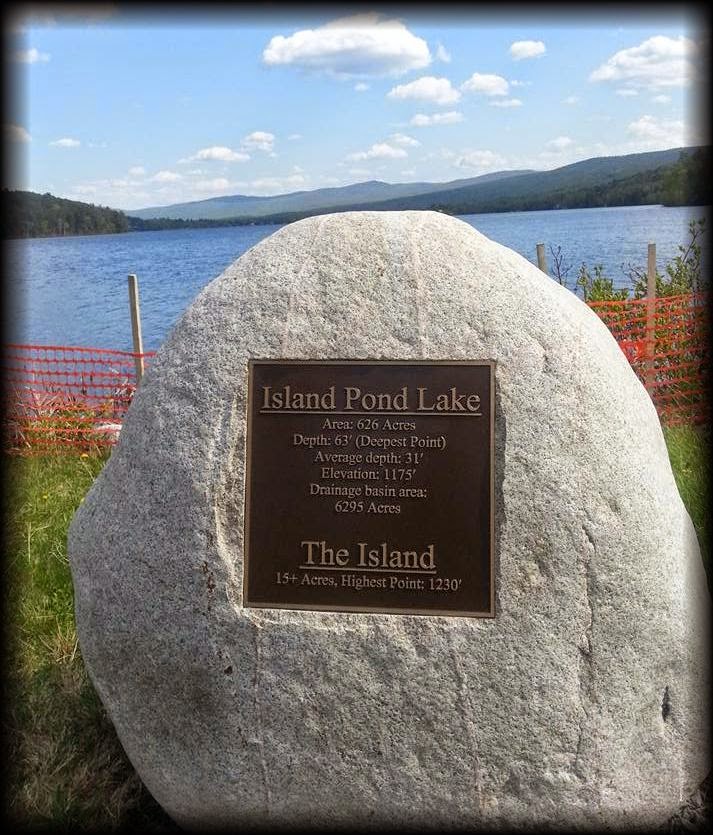
The Rock - At Island Pond
From here, we set our destination for the village Island Pond....just because.    Island Pond is actually a village of the Town of Brighton. Arriving there, I was struck with the architecture and how every building seemed to have been raised from a movie set.  I can't describe it, the lay out was just...different.  The pond located in the heart of the Village is very pretty, so Russ and I walked the path along the waterfront to get a cup of coffee and chill out for a while.


Island Pond
As we left Island Pond, we randomly traveled north-west onto Route 105, before turning south onto Route 5.  After traveling a relatively short time; suddenly before us was the unmistakable beauty of Lake Willoughby.  I am always awestruck by the mountain gap that allows the lake to run through.  It is a breath-taking view at any time of year.


Photo: Lake Willoughby: source unknown
Wind Power on Mountain top
Here I am, taking a short break, yesterday...Helmet head and all :)
To wrap up our excursion, I wanted to comment about the contrast in homes that I have noticed.  I suppose this is true anywhere, but since I live here, I tend to think about the contrasts of our environment.

It is interesting to me that you can be riding along and in one moment, you will pass by a very stately, well maintained home.  The lawn is immaculate and sometimes there are statues, or a gazebo, or perhaps an expensive landscaping theme.  Some are Federal style, some are Chateaus, and some are just plain gorgeous.

The flip-side is that it's neighbor will have a collapsing [mobile] home whose yard contains rusted cars and car-parts, a bathtub or toilet, wood pallets and piles; and other metal and wood debris piled to the sky and surrounding the entire "lawn".  Often this includes swing-sets commonly turned on their side and various other brightly colored plastic kids toys.  Sometimes you will see old school buses or trucks, abandoned, rusted and dead in their tracks on the side of their property or in an adjoining field.

The kicker is... often, next to the disheveled, garbage filled home and lawn, is a new immaculate 2 story garage....Go figure...

And, I almost forgot!  May 25th - Happy Birthday to me!

Here are some suggestions for your Day trip, somethings we learn the hard way!
Bug spray

Sunscreen
Sun-glasses
Gloves
Tool kit (we discovered our license plate was half off!)
Camera 
Cell phone 
Map or atlas - a physical one - don't rely on your GPS which will often try to take you on a dirt road that isn't part of the plan.
Scarf (optional)
Comb
Snacks
Blanket
Headlamp 
Spare reading or regular glasses (I wore contacts and my eyes were demon-colored by the time we arrived home)